Synopsis: On Sunday, January 17, a wind slab avalanche cycle on the east side of Mount Washington occurred following a period of moderate snowfall and wind. Two human-triggered avalanches occurred, one of which was widely publicized on social media and in the news. A number of factors led to the incidents which are worth looking into in order to shed light on some of the issues around the events. As is the case with many accidents, it is easy to pick out poor decisions in hindsight. In reviewing incidents, it is also rarely productive assigning blame to individuals compared to what lesson can be drawn. This incident presents an opportunity to highlight what appear to be trends in travel practices and decision making on Mt. Washington.
Weather: The snowfall leading up to the avalanche cycle was a typical upslope snow event which often follows more robust synoptic systems passing through our region. As an air mass is forced up and over the windward side of the range, the cooling process turns lingering atmospheric moisture into snow. In the case of the Sunday, January 17 avalanche cycle, the synoptic storm system had deposited 8” on the mountain on the prior Tuesday and Wednesday. A period of unsettled weather followed with 2” falling Thursday and Friday accompanied by periods of high winds and prolonged low visibility. A natural avalanche cycle occurred sometime during this loading event with the areas beneath Center Bowl and Chute later showing debris piles. By the pre-dawn hours on Saturday, as a Nor’easter passed offshore to the east, snow began to fall again during a 4 hour period of light SE and SSE winds. This snowfall became the weak layer when the wind shifted to the west and increased to the 50 mph range. By Sunday morning, sky conditions were clearing with W wind speeds in the 50’s mph lifting snow plumes with the previous days 5.5” snow (.55” SWE) from the alpine elevations. These plumes were visible from the parking lot at Pinkham Notch in the early morning hours. By 10am cold temperatures and blowing snow had begun to give way to clear skies, sunshine, and light wind.
Avalanche activity: By late morning, skiers and climbers began to test the slopes in both Ravines. Two skiers reported triggering a small slab (R1, D1) near Lunch Rocks beneath the Lip around 11am. One skier was carried about 20’ before arresting his slide. A little later, a guide entered South Gully in Huntington Ravine causing a slab to collapse and settle in place with no avalanche. At 12:50pm, an avalanche from the mid-section of Chute in Tuckerman Ravine caught and carried the two climbers who triggered the slide. Also caught were a solo skier crossing the runout on his way to Left Gully and two from a group of three skiers climbing up the track below the climbers. Of these five people caught and carried, two received minor injuries, with only one transported to a hospital. An avalanche course and a number of students were approximately 15’ from the moving debris on a 40 degree slope which had avalanched earlier in the avalanche cycle.
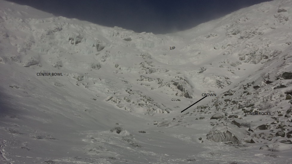
Chicken Rock Gully: SS-ASu-R1-D1, reported as 10-15cm deep, 15m wide, ran to elevation of the base of Lunch Rocks
A sub-feature in Tuckerman Ravine often referred to as Chicken Rock Gully. (image: MWAC, taken morning of Jan 17, 2016)
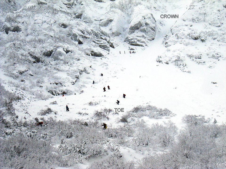
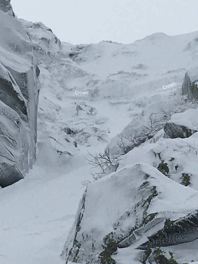
Chute: SS-AFu-R2-D1.5, estimated to be 10-50cm x 30m wide crown, 115m track of 400m path
A view into the Chute after the avalanche. Crown most likely wraps around out of view to the right. (image: nealpinestart.com)
Analysis: We have been seeing both positive trends in avalanche terrain travel choices and decision making as well as trends leaving room for improvement. Unfortunately, the trends needing improvement are all too common.
First, for the positives:
- Everyone involved was geared up appropriately for winter conditions with the right warm clothing, boots, etc. Despite the reputation Mount Washington has for “the world’s worst weather,” the number of travelers who come unprepared for the cold and wind is astounding.
- Some of the individuals involved were equipped and trained to apply first aid skills to the injured. Similar to the increasing trend in avalanche education we are seeing, there appears to be an increased interest in becoming more self-sufficient in the mountains. While at times Tuckerman and Huntington Ravines seem like frontcountry recreation areas with Snow Rangers and caretakers at both Harvard Cabin and Hermit Lake, it is important to remember that these locales are indeed backcountry settings and help can often be a long way away.
- Many of the individuals nearby, and one of the skiers who was in the path, were carrying avalanche rescue gear including beacons, probes, and shovels.
- Several Level 1 avalanche classes were in progress in Tuckerman Ravine. More and more people each year are seeking out professionally-taught avalanche courses which is a very good thing.
- At least some of the parties read the General Avalanche Bulletin issued on Saturday morning. This type of Bulletin is valid for up to three days, and was both in effect and posted Sunday morning. The Bulletin accurately described recent and upcoming snowfall and wind loading as well as the developed slopes which would become bed surfaces in this avalanche cycle.
Areas for improvement and lessons to take away:
- Of the five people caught in the avalanche, none were wearing beacons or carrying avalanche rescue gear. Sadly, this is not that unusual in our terrain. The avalanche class was wearing beacons and carrying rescue gear, as was one skier who was able to get out of the path as well as the two skiers who triggered Chicken Rock Gully. Frequently, climbers leave behind avalanche rescue gear to save weight, leaving no quick course of action should burial occur. Hats off to all who recognize the value of carrying avalanche rescue gear to be searchable and have the committed discipline to carrying it. The gear may or may not save your life should you get caught, but it certainly won’t help you if it is in your closet. Situations change, plans change, and mistakes happen—always carry the gear.
- Given the clustering of users near the Chute, it seems safe to assume that the Social Proof heuristic was at play. Following some discussion, the avalanche class chose to travel in steep terrain beneath a recently loaded slope. They were followed by the party of two climbers and the three skiers. Whether due to the easier travel following in someone else’s boot track, the erroneous assumption that a slope is safe because someone else already traveled on it, or the belief that other travelers know more than you, this behavior is all too common in Tuckerman Ravine. The two climbers then passed the avalanche class and ventured onto the unstable slope. This bunching in avalanche terrain forces constant re-evaluation of hazard. Additional challenges exist when trying to rebalance risk on a continual basis based on actions of others outside your control. This issue has been a factor in many avalanche accidents and fatalities locally, as well as around the world. Mount Washington has very concentrated avalanche terrain and has a high amount of visitation. We have seen on many occasions a group descend a route while others are unwittingly climbing up in the same avalanche path. This makes safe travel difficult when instabilities exist on a weekend on Mount Washington. Your party’s movements may be under tight control and stay within your chosen level of accepted risk, but only in the absence of other more unpredictable people. Take the same scenario, with other people as an uncontrollable variable, and you may increase your risk rapidly. This issue was demonstrated by this incident. We often see a compounding effect of visitors concentrating together in unstable conditions when they should be considering staying clear of one another by using fracture limiting terrain features and avoiding runout paths. This is certainly a major challenge for guided parties, courses and organized parties. Managing objective mountain hazards like icefall, avalanches, crevasses, etc. is hard enough, but adding subjective hazards due to other parties may be untenable. Every leader must balance the group’s level of skill with their agreed upon risk tolerance on a constant basis
- An associated concern to the above is the challenges of spreading out to reduce overall risk. While spreading out is a good, basic technique for traveling in or below avalanche terrain it may not be as effective as it is often assumed without a quality pre-plan to reduce risk. This pre-plan would review the actual benefits compared to truly going one at time, how you will communicate when spread out if new observations or decisions need to be made, and is this the best route. A best route option should always be a constant question. This can be a difficult decision because the safest route is often less convenient. Again, the effectiveness of spreading out as a team of 2 climbers, 3 skiers, or a large avalanche class are complicated when they are all interacting in the same terrain exposed to the hazards.
- The two climbers overlooked a red flag when they climbed over a recently reloaded crown line and onto a slope that rises from 40 to 45 degrees or more. Moreover, all parties involved in the Chute incident crossed beneath this slope within 4 hours of a period of active loading. While everyone chooses their own level of acceptable risk, it is unclear whether all parties involved sought out the information needed to make an informed decision by reading the posted General Avalanche Bulletin or seeking the right weather data. Hourly precipitation and weather data can be found here and is included among the list of other useful weather related websites on our site. These sites can be incredibly useful tools in the planning stages of your trip or even in the field when cell access is available (don’t forget a pocket charger or spare battery).
Lastly, a short discussion of MWAC’s published products, and any avalanche advisory for that matter, is worthwhile. It is a valuable topic to expand upon specifically. See “Avalanche Products” in our website Blog, ‘The Pit’ this weekend for a more in depth discussion.
- A General Avalanche Bulletin, which was published the day before these avalanche incidents, is used to convey hazards that are most typically a problem during the early and late season. This document is a one page narrative describing the hazards, but does not assign a danger rating. It is a broad discussion to highlight that instabilities and avalanche potential may currently exist, although not across the entire forecasting area in each Ravine.
- It is a common occurrence across the United States to see active visitor use in avalanche terrain and have avalanche accidents before a 5-Scale Avalanche Danger Rating Advisory is utilized. These occur under either Informational Bulletins or no products. These isolated instabilities are acceptable and tolerated without postings due to the limited nature of the issues. Incidents, although unfortunate, are a national actuality based on statistical probabilities and ever increasing backcountry use numbers. This fact clearly focuses to the importance of possessing avalanche knowledge and field skills. This is an important reality to note when entering any avalanche terrain whether in the Eastern or Western United States.
- Gaining and maintaining good avalanche assessment skills, training and experience is critical. If you don’t have this knowledge we would highly encourage you to get it through controlled learning environments versus relying solely on posted advisories. As stated in our Bulletins and Advisories, it is merely one tool to make field decisions. This is not a disclaimer; it addresses the complexity and nature of avalanches and the inevitable spatial variability we often see. If the Advisory states one thing and our dynamic weather creates another reality with increasing hazard, certainly go with your observations and neck hackles and not the advisory. Your future well-being makes it essential that avalanche skills match your desire for playing in the mountains. It will also help you draw as much as possible from the Advisory tool because we’ll be speaking the same language.


