Overview:
At about 12:00pm on Saturday, February 25, a party consisting of one skier and one snowboarder was involved in an avalanche incident on The Lip area of Tuckerman Ravine. One of the members of the team was caught, carried, partially buried, and uninjured. The avalanche was a large, hard slab and had the destructive potential to bury and kill a person. The avalanche danger for the day was rated CONSIDERABLE with wind slab as the primary avalanche.
Events:
*MWAC Forecasters interviewed the party about the incident and it should be noted that due a slight language barrier, there is still some uncertainty around the party’s decision-making process*
On the morning of February 25, the team of two created a plan to ascend the Lion Head Trail with the intention of descending a to-be-determined route in Tuckerman Ravine. They stopped at Pinkham Notch Visitor Center to read the current avalanche forecast before their approach. Both members of the group had previous backcountry experience in multiple snow climates and mountain ranges. Both people were carrying avalanche rescue equipment including a beacon, shovel, and probe.
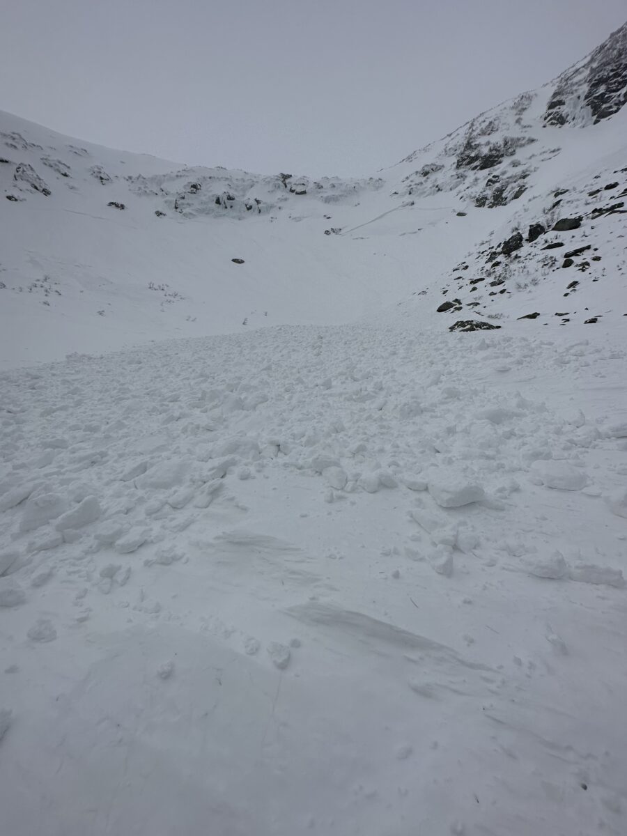
After passing the top of Lion Head, the party looked for the path of least resistance to descend into Tuckerman Ravine. This terrain choice ended up being The Lip, a steep, southeast facing convexity that rolls over into Tuckerman Ravine.
The snowboarder descended the constriction point and steepest part of the route first, then pulled off to the skier’s left side of the slope and waited for their partner to descend the same section. This stopping point was near the area of rock and ice that separates The Lip and Sluice terrain features. Though the snowboarder moved outside of the direct fall line of The Lip, they were still on a similar, connected slope.
With the snowboarder stopped to the side of the fall-line, the skier began descending the steepest and most constricted part of The Lip. During this part of the descent, they triggered a thin wind slab, which caused some debris to start to fall down the slope, and continued skiing. Just after, a hard slab fractured underneath the skier and propagated diagonally out in both directions. The skier was able to stop above the crown line, while the snowboarder was entrained by the hard debris, which slid down into and through Chicken Rock Gully into the Tuckerman Ravine floor. The snowboarder came to rest at the edge of Lunch Rocks and was partially buried to their waist. The party was able to self-extricate and did not sustain any injuries.
There were several witnesses of this incident and two of them captured good-quality video of the avalanche.
Avalanche Statistics:
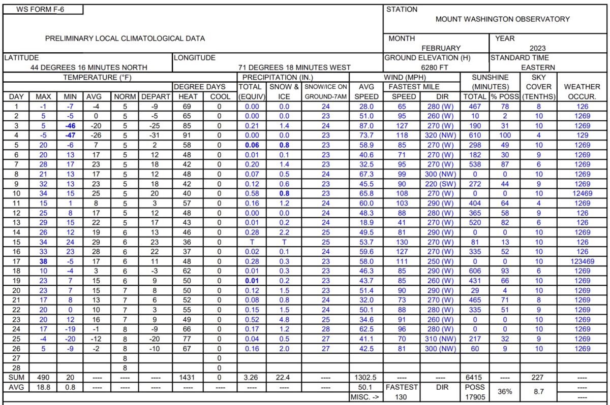
Type: Hard Slab
Trigger: Skier, unintentional
Aspect: Southeast
Slope Angle: 45 degrees
Size: R2 / D2
Elevation: 4800 feet
Sliding Surface: New / Old Interface
Vertical Fall: 400 feet
Width: 125 feet
Debris depth: About 5 feet maximum
Snowpack:
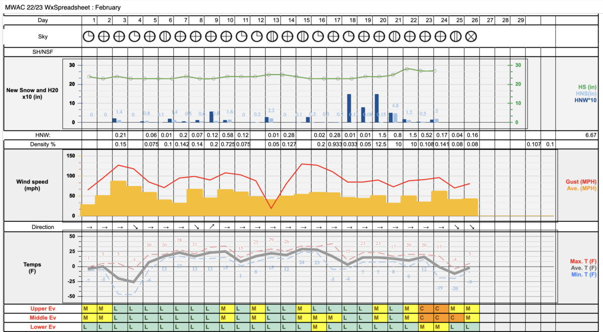
On February 17, the Mount Washington Summit reported a high temperature of 38 degrees F. Additionally, 0.28 inches of precipitation fell as mostly rain and freezing rain during that 24-hour period. The subsequent refreeze in the following days created a very hard melt/freeze crust layer that can still be found buried 3 or more feet below the surface of the snow where there has been an adjacent layer of soft snow, facets, and graupel. This crust has acted as one of the bed surfaces in the most recent natural avalanche cycle.
Some slight snow accumulation continued for the next several days until a more significant winter storm event began on the night of February 22nd. On February 21st and 22nd, prior to the storm, sunny conditions, mild temperatures, and significant radiation gain into the snowpack on southerly aspects fostered a process of radiation recrystallization. This formed a thin crust layer with adjacent faceting of the snow in many areas and also acted as one of the bed surfaces in upcoming avalanche activity.
On February 22nd – 24th, new snow and wind drove wind slab development across east-facing and south-facing avalanche terrain and resulted in several natural avalanches during and immediately post storm. The thin crust layer was buried 1 – 2 feet down in most lee terrain. The February 17th melt/freeze crust was buried roughly 3 or more feet deep in lee terrain. See the observations page for more information about this activity.
In the case of this human-triggered avalanche, it appears that the thin facet layer from Feb. 21 and 22 failed first under the weight of one (or two) skiers before stepping down into the deeper instability (soft snow above February 17th crust). This snowpack setup, as well as the increased sensitivity of new wind slabs drove the hazard rating decision for that day which was CONSIDERABLE at middle elevations and MODERATE at upper elevations.
Summary:
When interviewing the group, it was not completely clear that they had understood the avalanche forecast or the location of that day’s avalanche problem. They were navigating with a map but did not have familiarity with the terrain in Tuckerman Ravine. They chose to enter this terrain with a false assumption of stability, which ultimately proved to be inaccurate. This incident, and especially the quality video that goes along with it, is a great example of the characteristics and danger of a hard slab avalanche.
We are happy that the party was not injured and has learned from this experience. We hope that this near miss is also a great learning opportunity for other backcountry enthusiasts who travel in this terrain. What if this party skied the slope in the same conditions but didn’t trigger this avalanche? What would they have told themselves about how the day went? What would they have told others asking about skiing the same thing? What if the runout was a funnel-shaped terrain trap? It is worth reflecting on questions like these while also thinking about our own terrain choices and travel techniques to minimize risk for ourselves and for others.